Area Chased: C OK
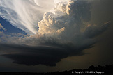
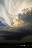
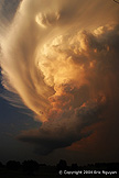
Discussion: At 6ish I noticed a blip on radar near Purcell along a stationary front that stretched from E OK to LBB. I walked outside and observed a large tower exploding to my due south. I wasn't expecting convection to fire, however, it looked like this one was definitely going to last and become a supercell, so I went east on Hwy 9 and south on 102 where I encountered some hail with baseballs on the ground north of Byars, OK. I took some time to collect samples of the already melted hail which came out to 2.25 - 2.75 inches in diameter. I went south and caught up with the meso north of Stratford on Hwy 177. It had moderate rotation with a wallcloud and it appeared to have some great structure, so I dove south to get some wide angle shots of the storm. The view was incredible, however, the classic appearance was changing more towards an LP with no precip and less organization. Still, a beautiful supercell during sunset as it slowly weakened.
Pictures:
 Looking outside my from door at a developing storm.
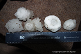
 Hail at 2.25 - 2.75 inches in diameter just north of Byars, OK.
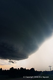 North of Stratford, OK, excellent structure.

 Stacked plate meso north of Stratford on Hwy 177 looking north.
