- 2004 June 18
- © Copyright 2004 Eric Nguyen
-
- Chase Area: Northeast New Mexico
- We began the day in Clayton, New Mexico, and targeted upslope in
Northeast New Mexico for potential supercells. Image showing the location of the
supercells we observed marked as a red dot.

-
- Distant Convection
- While driving south we began to observe convection off to our
southwest along the front range of the Rocky Mountains. We knew we had to get south
and flank this or any other storm that would develop along the region of upslope flow.

-
- Hmmm... No Good Road Options
- Scott Blair and I have taken this road before and we did not like it!
We didn't have much of a choice as this was the only road going south. It
began as a decent pave road, then turned into a gravel dirt road, then into a muddy mess.
Two storms tracked over this road previously which turned the more difficult part
of the road into a slippery mess. When we reached the mud we drove about 15-20mph
and didn't stop, else we would be stuck there for a day or so. We had limited cell
coverage, so we made a quick call to someone that would call a tow truck if we didn't call
back in 45 minutes. At one point I had my steering wheel turned in order to keep
straight, the front tires were not moving at all. Luckily we did reach the main
highway, just in time for our storm to begin organizing.


-
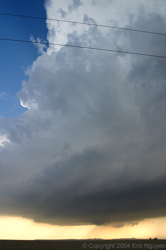
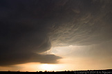
- Supercell Thunderstorm
- The storm tracked over the messy road we were on while moving slowly
east. It quickly began to exhibit supercell characteristics as it organized into an
LP supercell. This was certainly not a storm where one would want to be underneath
it, the main show was clearly the structure! With time, a lowering developed hinting
at some low level organization, however, it didn't last long.


-
- New Convection to our East
- New strong convection developed back to our east near the Texas
border. Our storm however was still organized and as it moved east, encountering
deeper moisture, which resulted in further intensification. More storms began to
develop all around us at sunset which made chasing more difficult, especially giving the
very poor road network. At one point, we took a "trail", which was no more
then two tire tracks leading off into the prairie. This was the only road option we
had on GPS, so we took it. It occasionally ended at farm houses, but then would pick
back up leading off into the hills. Scott and I thought we were the only ones
foolish enough to be out there until we were passed by Dave Gold and Silver Lining Tours.
Once we reached pavement we called it a day and headed to the nearest hotel.
That evening as the MCS was passing over our hotel, we talked with Dave Gold over the poor
prospects of chasing the new few days. Summer was setting in and we were concerned
that shear and instability were not good enough for storms the new few days.


- © Copyright 2004 Eric Nguyen
-
- or