Area Chased: NW TX
Discussion: A setup for tornadic supercells appeared possible over NW and C TX along two outflow boundaries in a strong shear high instability environment. The midlevel flow was forecasted to be WNW by 00z, so we were dealing with storms that would probably lean towards going HP with high winds and hail being the main threat. I don't particularly like NW flow events but this one looked good enough to go after. Besides, it was only June 1st!
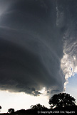
We went south to FTW to pick up Jeff Lawson, and then drove east towards a developing supercell near Weatherford. This storm moved SE into a horrible windy road network that was packed with many travelers probably driving home from work at DFW. This reinforced my future commitment never to go south of I20 again, however, as our storm began to weaken some, the LP looking updraft detached from the main precip core. This may have been an old occluded updraft or the updraft itself as the storm weakened rapidly on radar. After seeing that awesome view, we went north to a storm that was dropping softball sized hail. By the time we caught up to it, it was a major HP with 1-2 inch hail and 50-60mph winds. There was another cell to its west, so we waited a bit for that one in the same town and got the same results, lots of rain and small hail. To the west of that storm was another smaller storm in the twilight. We took some stills of that hoping to get some anvil crawlers, and called it a day.
Pictures:
 As the supercell's core too off to the east, we were left with a
sculpted updraft.

 Images of both sides of the supercell, decent rotation was
occurring with this storm.
 After that storm dissipated and another to our north went HP, we
looked back to our west to see a friendly looking storm.

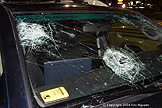
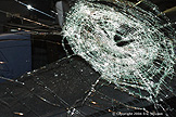
 A friend of ours was on the storm south of Wichita Falls and got
some baseball and softball sized hail, which took his sunroof out completely as well as
bashing parts of his car including the front window.