Area Chased: SC KS
Discussion: Scott and I had one of the best chases of our lives. We targeted southern Kansas in the vicinity of the dryline bulge and a weak W-E boundary. We waited in Medicine Lodge, KS, and had a storm develop to our SW near Hardtner, KS. We followed this for a little over an hour before it gave any signs of becoming a supercell. We observed a horizontal funnel pointing south near Attica, KS. This quickly developed into a gorgeous tornado! This tornado lasted 24 minutes and had an incredible rope out. During the rope out of the Attica tornado, another tornado developed to our SE in the shape of a large cone. We blasted east and once again, found ourselves in Harper, Kansas observing a wedge to our immediate south. We successfully flank the tornado and watched as it slowly moved north just west of Argonia, KS. This became a large wedge tornado moving due north. We had a sudden wind shift and noticed that a wallcloud had passed overhead and was quickly about to produce another tornado. So we blasted east to flank this tornado. It produced a large stove pipe orange in color from the setting sun. This tornado also morphed into a wedge as it moved northward. We ended the day with two tornadoes on the ground again.
Pictures:
 Despite the fact that our storm kept having updrafts occlude and
rapidly dissipate, it finally got its act together near Attica, KS, where the partial
occluded updraft began to rapidly rotate. Also, strong downward motion could be seen
this time in the RFD region.
Despite the fact that our storm kept having updrafts occlude and
rapidly dissipate, it finally got its act together near Attica, KS, where the partial
occluded updraft began to rapidly rotate. Also, strong downward motion could be seen
this time in the RFD region.


 A tornado quickly developed and moved northward. The first
signs of a circulation at the surface was at 0025 UTC.
A tornado quickly developed and moved northward. The first
signs of a circulation at the surface was at 0025 UTC.

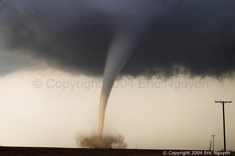
 At times the sun illuminated the bottom half of the tornado
making an absolutely amazing site! The far left image is taken at 0031 UTC looking
due north.
At times the sun illuminated the bottom half of the tornado
making an absolutely amazing site! The far left image is taken at 0031 UTC looking
due north.

 The tornado had some intense motion at ground level with the tube
making several kinks. This tornado moved slowly to the ENE, appeared stationary, and
then began to have a westward track.
The tornado had some intense motion at ground level with the tube
making several kinks. This tornado moved slowly to the ENE, appeared stationary, and
then began to have a westward track.


 Stills an amazing site as this tornado kept on going.


 More amazing images as the updraft began to tilt over and
occlude. The second image to the left is taken at 0042 UTC looking north as the
updraft appears to be leaning towards the NE.
More amazing images as the updraft began to tilt over and
occlude. The second image to the left is taken at 0042 UTC looking north as the
updraft appears to be leaning towards the NE.


 The entire updraft occluded as the tornado itself roped out
behind blue skies! The last image I took was just prior to the demise of the visible
circulation at the surface, taken at 0049 UTC, making the time of this tornado lasting 24
minutes.
The entire updraft occluded as the tornado itself roped out
behind blue skies! The last image I took was just prior to the demise of the visible
circulation at the surface, taken at 0049 UTC, making the time of this tornado lasting 24
minutes.
 While the 1st tornado was going there was another tornado
developing to our southeast and something developing to the north of that possibly.
Also, notice the tube on the top of the image. This was well after the tornado had already
initially developed and only video will show when it began, time of image is at 0057 UTC
looking ESE.
While the 1st tornado was going there was another tornado
developing to our southeast and something developing to the north of that possibly.
Also, notice the tube on the top of the image. This was well after the tornado had already
initially developed and only video will show when it began, time of image is at 0057 UTC
looking ESE.

 We left the 1sts tornado once it completely occluded and met up
with the second tornado as it rapidly developed into a big dusty wedge. Images taken
at 0108 UTC looking SSE.
We left the 1sts tornado once it completely occluded and met up
with the second tornado as it rapidly developed into a big dusty wedge. Images taken
at 0108 UTC looking SSE.


 We luckily flanked the tornado with a view now looking due west
at wide angle. It had broad area of strong rotation as it began to lift and
reorganize. The far left image was taken at 0114 UTC looking at a road that goes due
east out of Argonia, KS.
We luckily flanked the tornado with a view now looking due west
at wide angle. It had broad area of strong rotation as it began to lift and
reorganize. The far left image was taken at 0114 UTC looking at a road that goes due
east out of Argonia, KS.


 It didn't take long for it to develop into a large cylinder
shaped tornado. We left this tornado to pursuit the tornado 1/2 mile to our east.
Far left image was taken at 0121 UTC looking almost due east as the tornado moves
northward. It is about 1.5 miles away and just west of Argonia, KS. The
tornado grew into a wedge shaped tornado as it slowly moved northward wrapping in rain at
0130 UTC, NE of Argonia, KS. We left this tornado to pursuit one that was developing
a half mile to our east. The tornado you see in these photos eventually dissipated
at 0149 UTC, which can be seen in images below. This puts the life of the tornado
over 52 minutes, probably closer to 60 minutes.
It didn't take long for it to develop into a large cylinder
shaped tornado. We left this tornado to pursuit the tornado 1/2 mile to our east.
Far left image was taken at 0121 UTC looking almost due east as the tornado moves
northward. It is about 1.5 miles away and just west of Argonia, KS. The
tornado grew into a wedge shaped tornado as it slowly moved northward wrapping in rain at
0130 UTC, NE of Argonia, KS. We left this tornado to pursuit one that was developing
a half mile to our east. The tornado you see in these photos eventually dissipated
at 0149 UTC, which can be seen in images below. This puts the life of the tornado
over 52 minutes, probably closer to 60 minutes.


 As we watched the previous tornado we encountered some strong
inflow winds racing into a large lowering which eventually became another tornado 6 miles
NE of Argonia, KS. Since we appeared to be the only souls in the vicinity, I was
calling 911 frequently to report the progress of the aforementioned tornado as well as the
developing new tornado which developed a debris cloud at around 0134 UTC.
As we watched the previous tornado we encountered some strong
inflow winds racing into a large lowering which eventually became another tornado 6 miles
NE of Argonia, KS. Since we appeared to be the only souls in the vicinity, I was
calling 911 frequently to report the progress of the aforementioned tornado as well as the
developing new tornado which developed a debris cloud at around 0134 UTC.


 This tornado moved northward as the older tornado eventually
dissipated as seen on the third image. Third image taken at 0149 UTC looking NNE.
This tornado moved northward as the older tornado eventually
dissipated as seen on the third image. Third image taken at 0149 UTC looking NNE.


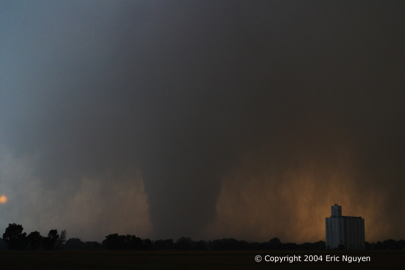
 This tornado grew quite large and based on video appeared to be a
strong to violent tornado. Far right image taken at 0153 UTC looking due north as
the tornado slowly moved northward.
This tornado grew quite large and based on video appeared to be a
strong to violent tornado. Far right image taken at 0153 UTC looking due north as
the tornado slowly moved northward.

 As this tornado eventually began to rope out, another tornado
developed to the northeast and as it moved westward grew into a large tornado, just north
of the white stove pipe shaped tornado seen here. I would have taken stills,
however, it was getting dark and the rotation seemed strong enough that it was blurring
with a one second exposure. Video captures will have to be implemented after these
series of images. The last image was taken at 0200 UTC, which puts the tornado time
on this one at 26 minutes, with this tornado continuing on its slow northward track.
The tornado that grew quite large north of the weakening one developed into a large
tornado west of I-35 before dissipating into a thin stove-pipe tornado near I-35. I
don't have many details as it was getting dark and the video was the primary way we
documented the end of this event.
As this tornado eventually began to rope out, another tornado
developed to the northeast and as it moved westward grew into a large tornado, just north
of the white stove pipe shaped tornado seen here. I would have taken stills,
however, it was getting dark and the rotation seemed strong enough that it was blurring
with a one second exposure. Video captures will have to be implemented after these
series of images. The last image was taken at 0200 UTC, which puts the tornado time
on this one at 26 minutes, with this tornado continuing on its slow northward track.
The tornado that grew quite large north of the weakening one developed into a large
tornado west of I-35 before dissipating into a thin stove-pipe tornado near I-35. I
don't have many details as it was getting dark and the video was the primary way we
documented the end of this event.
I'll be going through GPS and video to produce my typical log of the life cycle of this storm and the associated tornadoes.