- 2004 May 12
- © Copyright 2004 Eric Nguyen
-
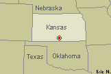
- Chase Area: South Central Kansas
- Scott Currens and myself left Grand Island
that afternoon towards our target in southern Kansas. We enjoyed the crisp cool air
north of the front and as we made our way south. During the early afternoon hours,
strong pressure falls began to occur over most of the southern plains with a surface low
expected to develop in southeast Colorado. Flow aloft by 00z was expected to be
sufficient reaching 30-35 knots at 500mb. Boundary layer winds were forecasted to
back significantly as the strong surface low developed in Colorado, thus increasing low
level shear (BRN shear values reaching 80 m^2/s^2). Instability was forecasted to
become quite strong with CAPE values reaching 3000 j/Kg. Thus it appeared that there
would be a significant chance for tornadic supercells in the vicinity of the front /
dryline intersection. Image showing the location of the supercells we observed
marked as a red dot.
-
- Convection Fires
- While watching the initial convection firing along the OK/KS border,
we were treated to some mammatus overhead. Many storms were developing so we were
monitoring them all closely visually and on radar. Finally, there were two cells we
found interesting to our immediate south.

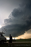
- LP Supercell Develops
- We drove south towards a storm developing west of Sharon, Kansas,
when we looked back to our north we saw this incredible rotating LP supercell.
Despite what the Attica storm looked like on radar, and Martin Lisius passing by telling
us there was a big tornado to our south, we opted to stay on this storm. This storm
sat stationary north of Medicine Lodge, Kansas, and eventually produced a weak
tornado. Mean while, the storm near Sharon moved east towards the town of Attica,
Kansas.
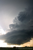


- Time to Head South
- As our storm lost organization, we blasted southeast to a storm not
far from our location which was also tornado warned. While in route, we observed
eddies on the back side of the storm. We reached the town of Harper, Kansas and
observed a very large mesocyclone, with a large tornado developing to our southwest and
another tornado to our southeast. We opted to pursuie the newer tornado and got
close for video rather then hanging back and doing long exposure stills. Long
exposure was required due to the low light as the sun had set and we were under a massive
supercell. I unfortunately got no good stills of this part of the event, however
Scott got some excellent video. When we got close to the wedge that moved northward,
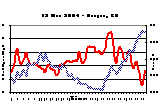
and then curved back east, we encountered some strong winds exceeding 80mph, which is
plotted below.


- Storm Rages Through The Night
- As the storm moved east of Harper, Kansas, it slowed and almost
seemed to become stationary as it produced a series of night-time tornadoes. We
flanked the storm too far to the east to really get a great view of the tornadoes, however
we observed them from a distance. After that we blasted east to shoot structure.
We ended the day in near Wellington, Kansas, along I-35.


- © Copyright 2004 Eric Nguyen
-
- or


