- 2004 May 9
- © Copyright 2004 Eric Nguyen
-
- Chase Area: Northeast Nebraska
- We began the day in Omaha, NE and drove to
Sioux Falls, SD to wait for initiation. Strong TCU developed to our south near
Vermillion, SD and points eastward. Storms appeared high based and disorganized,
however, the storm over Vermillion began to back-build southwestward, basically sitting on
top of the town. We took photos of the updraft on the backside and noted a tornado
warning that was issued for that cell despite the 30 degree dewpoint
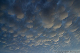
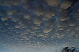
depressions. Storms back at O'Neil, NE gave us an incredible display of
mammatus during sunset.

-
- Severe Storm
- View looking north at the storm over
Vermillion, South Dakota, as it pretty much sat stationary. With 30 degree dewpoint
depressions we were surprised to see a tornado warning go out on it. Structure
looked decent and once it began to weaken we drove westward to get in position for
tomorrows target in western Nebraska.

-
- Mammatus Everywhere
- Near the town of O'Neil, Nebraska, we
encountered a sky full of mammatus clouds.

- © Copyright 2004 Eric Nguyen
-
- or


