- 2004 April 9
- © Copyright 2004 Eric Nguyen
-
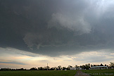
- Chase Area: Southeast Oklahoma
- Scott Currens and I departed around 1pm to
Ardmore, Oklahoma. We watched towering cu form and die and finally we got a
persistent updraft just east of Ardmore. It quickly organized into a decent
supercell in the vicinity of an old boundary.

-
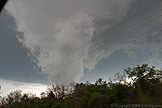
- Rapid Upward Motion
- We got under the updraft and observed
rapidly lifting scud in the vicinity of a rotating wallcloud. We could see
short-lived thin funnel tubes embedded in the wallcloud. Despite how organized it
looked, it eventually lifted and the base got higher with time.
-
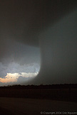
- Road Closed
- We chased this storm as long as we could
until we hit a road that was blocked. The road likely ended in the red river a half
mile down the road. It was getting late anyway so we observed what was left of the
storm with an intense core and rainfoot.
- © Copyright 2004 Eric Nguyen
-
- or


