Area Chased: SE SD
Significant Observations:
- Go here for a log of the chase: June 24, 2003 LOG
Discussion: Scott Blair and I observed 11-13 individual tornadoes as well as amazing structure from one cyclic mega-supercell. I'm writing this in January 04 so I don't have time to go into details, check out the log above.
Pictures:
 Around 0000 UTC to our north a large rotating wallcloud.
Saw a cone to the north of that wrapped in rain, however we could not confirm anything
other then that.
Around 0000 UTC to our north a large rotating wallcloud.
Saw a cone to the north of that wrapped in rain, however we could not confirm anything
other then that.

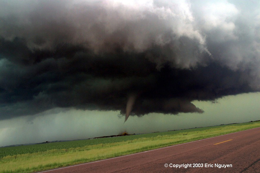
 0018 UTC multiple vortex tornado rapidly developing 8 SSW of
Centerville, SD.
0018 UTC multiple vortex tornado rapidly developing 8 SSW of
Centerville, SD.
 Scott and I blasted east and north on the road seen in the image.

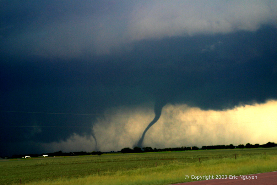
 Multiple vortex structure, many funnels aloft embedded in violent
rotation, 2 NW Centerville, SD. Anticyclonic funnel observed aloft.
Multiple vortex structure, many funnels aloft embedded in violent
rotation, 2 NW Centerville, SD. Anticyclonic funnel observed aloft.


 Tornado near Centerville, SD, multiple vortex. New funnel
seen east as this tornado moves westward.
Tornado near Centerville, SD, multiple vortex. New funnel
seen east as this tornado moves westward.


 New meso east of the Centerville tornado as it continues west and
wraps in rain. This tornado is 2-3 E of Centerville, SD and is stationary.
This is the 3rd tornado of the day for us.
New meso east of the Centerville tornado as it continues west and
wraps in rain. This tornado is 2-3 E of Centerville, SD and is stationary.
This is the 3rd tornado of the day for us.

 Tornado #4 develops 1 E of Centerville, this formed west of
tornado #3, both are on the ground now. We hit a damage path from one of the
satellite vorticies, note the power lines over the road. No good still of tornado #5
yet.
Tornado #4 develops 1 E of Centerville, this formed west of
tornado #3, both are on the ground now. We hit a damage path from one of the
satellite vorticies, note the power lines over the road. No good still of tornado #5
yet.
 Tornado #6 develops just to our NW, an image showing some of the structure that we can't
see due to being under the meso. This developed 4 NE of Centerville, SD.
Tornado #6 develops just to our NW, an image showing some of the structure that we can't
see due to being under the meso. This developed 4 NE of Centerville, SD.


 We observed many multiple vorticies under this wallcloud to our
NW as it moved westward, this was all tornado #7 until the wallcloud occluded..
We observed many multiple vorticies under this wallcloud to our
NW as it moved westward, this was all tornado #7 until the wallcloud occluded..


 Tornado #8 on the left, multiple vortex tornado that gets big as
tornado #9 tries to get ingested, however, it begins to move east as the larger tornado
moves west towards Davis SD.
Tornado #8 on the left, multiple vortex tornado that gets big as
tornado #9 tries to get ingested, however, it begins to move east as the larger tornado
moves west towards Davis SD.

 We got gas and went back to the storm as it quickly got dark.
This new tornado wrapped in rain is doing damage near Lennox as the storm
propagated back to the SW, back towards Lennox, SD. On radar it looked like a new
meso formed west of the older one.
We got gas and went back to the storm as it quickly got dark.
This new tornado wrapped in rain is doing damage near Lennox as the storm
propagated back to the SW, back towards Lennox, SD. On radar it looked like a new
meso formed west of the older one.

 Amazing structure as the tornado potential continues and the
chase gets more dangerous.
Amazing structure as the tornado potential continues and the
chase gets more dangerous.


 Wallcloud somewhere in South Dakota, lol. The other
nighttime tornadoes didn't come out on stills very well so perhaps I'll add some video
captures in the future. We got off the storm for safety reasons, reports of a large
tornado just to our SW on another storm forced us to head to Sioux Falls, SD and find a
decent place to not get hit by anything significant. We captured some of the
structure of our storm moving off to the north.
Wallcloud somewhere in South Dakota, lol. The other
nighttime tornadoes didn't come out on stills very well so perhaps I'll add some video
captures in the future. We got off the storm for safety reasons, reports of a large
tornado just to our SW on another storm forced us to head to Sioux Falls, SD and find a
decent place to not get hit by anything significant. We captured some of the
structure of our storm moving off to the north.