Area Chased: TX PAN
Discussion: Started out in ABI waking up to a classic setup for significant supercells. Very high CAPE values along with more then sufficient shear, plus an old outflow boundary that extended from about ABI to LBB. We expected storms to form at the boundary intersection along the dryline somewhere near LBB. Dave and I went west to Snyder, TX stopping for a leisure lunch at Grandy’s and getting data at the same time. We saw the dryline shaping up along the TX / NM border and the outflow boundary going from north of ABI to about LBB curving up to the dryline NW of Littlefield, TX. We went northwest to LBB and did some shopping at BestBuy and getting data at the computer department there. Conditions just to our NW still appeared to be the best chance for significant supercell development.
We proceeded NW towards Littlefield, TX and began to see a huge tower to our northwest. It had huge explosive back-building towers on the SW side. We went north towards Dimmit, TX and saw a pretty high based rain free base just to our SW. It had some weak scud rising into it with signs of the base lowering. Despite NOAA giving a NE trajectory at 45mph, the storm moved very slowly ENE. We went north toward Hereford, TX and quickly experienced baseball sized hail which busted the windshield on my side this time. (note, previous day we busted out the left side of the windshield with my side being relatively clear) This gave us a hint that this storm was extremely strong and as we suspected, it just lacked some low level organization. We stopped to take pictures of the baseballs on the ground and proceeded east on country road 605 / ranch road 1075 toward Arney, TX. At this point we now had a little bit lower base with organized rotation. Still, it was high based and seemed to be getting undercut by outflow. We proceeded east on ranch road 1075 and went north on ranch road 1075 as it curved. At this time something happened to this storm where an extremely intense low level mesocyclone developed which quickly produced a wall cloud with rising dust / tornado touch down. During the amplification of the low level mesocyclone, we experienced ESE SFC winds exceeding 45mph (measured). It quickly became a very low hanging wall cloud with multiple vorticies. We stopped a 1/2 mile south of the tornado to setup the tripod and shoot video / stills. Tornado became a large cone then a wedge. It lasted for several minutes and then eventually, it became wrapped in a little rain and dust and quickly dissipated. So we went north on 1075 and east on Country Road C as 1075 looked to have been hit by the tornado. Tornado moved NNE toward the town of Happy, TX but dissipated before getting close to town. However, a second large cone tornado formed just west of town and moved in, where unfortunately some significant damage occurred including loss of life. We drove east on Country Road C which became Ranch 1881 going due east. We got east of highway 27 and stopped to film / shoot slides of the new cone shaped tornado to our NW.
After the tornado dissipated we continued to watch this storm moving east on 1881 and eventually working our way north to 1075 still going east. To stay ahead of this massive wall cloud, we moved north a mile and then east on Ranch 285 where we had to stop at road 207 which ended our eastward routes. A chaser convergence occurred there where we all wondered where to go next. Most decided to go south on 207 back to Silverton, TX. The chase seemed to be closer to ending as daytime was down to 30 minutes left.
At Silverton, TX, Dave and I went SE on 86 towards Turkey, TX which turned NE toward ranch road 657. Scott Blair was telling us there was still a huge supercell with 77 VIL and a hook heading toward LakeView, TX. While northbound, I suddenly saw huge power flashes to my north. Each power flash lasted several seconds. I stopped at the intersection of 657 and 1041 just west of Plaska, TX. I estimated it to be 1-2 miles to our NNE which would be 3 miles south of Lakeview. At the same time, Scott Blair gave me an update about Doppler radar showing over 100kts on the south side of this storm, showing strong RFD winds. This caused lots of damage over Lakeview and eventually Memphis, TX. We went west on 1041 and then north on 2472 to avoid the damage in Lakeview. We heard of power lines blocking the roads just west of Lakeview. We took a right on 256 toward Memphis, TX and saw quite a bit of tree and power line damage as well as numerous trucks blown over. We continued east on 256 to keep up with this storm as it had a significant lowering just north of the road. We continued east avoiding occasional debris from tree’s and big black cows resting on the road. At one point we all stopped as a cone shaped funnel appeared to be just to our due east. RJ Evans and Bobby Prentice were stopped as well watching this thing. Jason Poliette quickly joined on the side of the road and we all watched closely at each lightning strike. It quickly widened and appeared to be a huge wedge tornado or possibly a very low significant wall cloud. At this time its unconfirmed.
With little gas left, we opted to go south on 62 to CDS to get gas and food and call it a night. We met up with everyone else and ate dinner. That’s when we heard 2 were killed in Happy, TX with 10 missing.
The past two days have been the most dramatic to my vehicle. I’ve chased with several vehicles before but this van wins the award for most pounded by mother nature! We had tennis ball to baseball sized hail dents all over with our window shattered, parts broken including my high beam bulbs for some reason. To top it off, the damage we drove through in Memphis damaged the side wall of my back tire. Dave and I, already exhausted from lack of sleep and chasing the past two crazy days, changed the tire and continued back to DFW. The next day it looked like we'd be heading to C KS. We got to DFW by 4am and as I finish this chase document its 5:10am.
Pictures:
 The Happy, TX storm in the early development stage near Dimmit, TX. We
actually refereed to it as the Dimmit storm until it produced the large tornado near
Happy. Image shows a jet going around the storm rather then over it or threw it.
The Happy, TX storm in the early development stage near Dimmit, TX. We
actually refereed to it as the Dimmit storm until it produced the large tornado near
Happy. Image shows a jet going around the storm rather then over it or threw it.
 We watched the storm develop a weakly rotating wallcloud which quickly got
undercut.
We watched the storm develop a weakly rotating wallcloud which quickly got
undercut.


 We allowed the updraft to pass only a few miles to our east so we
could get a glimpse of the size of the hail and take some images of the updraft.
It's always a treat to get to see the updraft of your storm! The base was only a few
miles away so I had to shoot looking almost straight up. With my wide angle lens,
that's all I could fit on there. Hail was large, Dave got some great video of tennis
ball to baseball hail hitting a wet plowed field. Once the hail subsided we got out
and took a few images of the melting hail. Image shows Dave holding a 2 inch hail
stone.
We allowed the updraft to pass only a few miles to our east so we
could get a glimpse of the size of the hail and take some images of the updraft.
It's always a treat to get to see the updraft of your storm! The base was only a few
miles away so I had to shoot looking almost straight up. With my wide angle lens,
that's all I could fit on there. Hail was large, Dave got some great video of tennis
ball to baseball hail hitting a wet plowed field. Once the hail subsided we got out
and took a few images of the melting hail. Image shows Dave holding a 2 inch hail
stone.


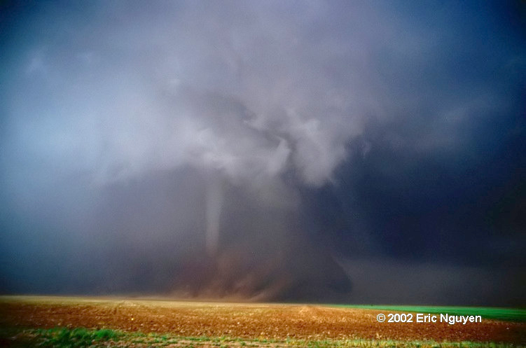
 We moved east and then north to get near this developing
tornado. Video showed us to be about 1/2 mile away from the tornado when it
initially developed. It slowly moved north and then east when it began to weaken.
We moved east and then north to get near this developing
tornado. Video showed us to be about 1/2 mile away from the tornado when it
initially developed. It slowly moved north and then east when it began to weaken.
 A second tornado formed just west of Happy, TX and moved east
killing two. It began as a large cone tornado which came out well on video rather
then slides.
A second tornado formed just west of Happy, TX and moved east
killing two. It began as a large cone tornado which came out well on video rather
then slides.

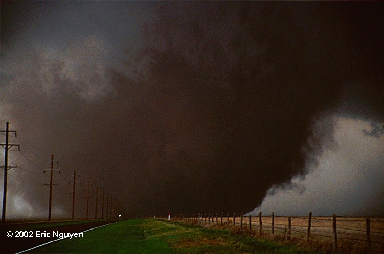
 This image didn't scan well, however, it shows how low the base
of the storm was at sunset as it began to go off the caprock. We went south due to a
lack of road options as the storm moved off the caprock. We quickly caught up to it
south of LakeView, TX.
This image didn't scan well, however, it shows how low the base
of the storm was at sunset as it began to go off the caprock. We went south due to a
lack of road options as the storm moved off the caprock. We quickly caught up to it
south of LakeView, TX.